NEWFree download · Colour & B/W prints in A0–A5 at Hexagon Photostat, Arera Colony — order your print
★ Draft published 26 September 2026 · Claims & objections invited

Bhopal Development Plan 2047 (Draft): Download the Map & Get It Printed

The Madhya Pradesh government has published the draft Bhopal Development Plan 2047 — the land-use blueprint for the capital. Download the draft map as a PDF or image, understand the zones and proposals in plain language, and order a sharp colour or black & white print from our shop in Arera Colony.

Updated 28 September 2026 · Map source: Directorate of Town & Country Planning, M.P. (Map No. 14.2)

1,016.90 sq kmInvestment area
254Villages covered
≈ 45 lakhEstimated population
61,017 haProposed developable area
51 kmGrowth corridor
27%Green area proposed (from ~16%)
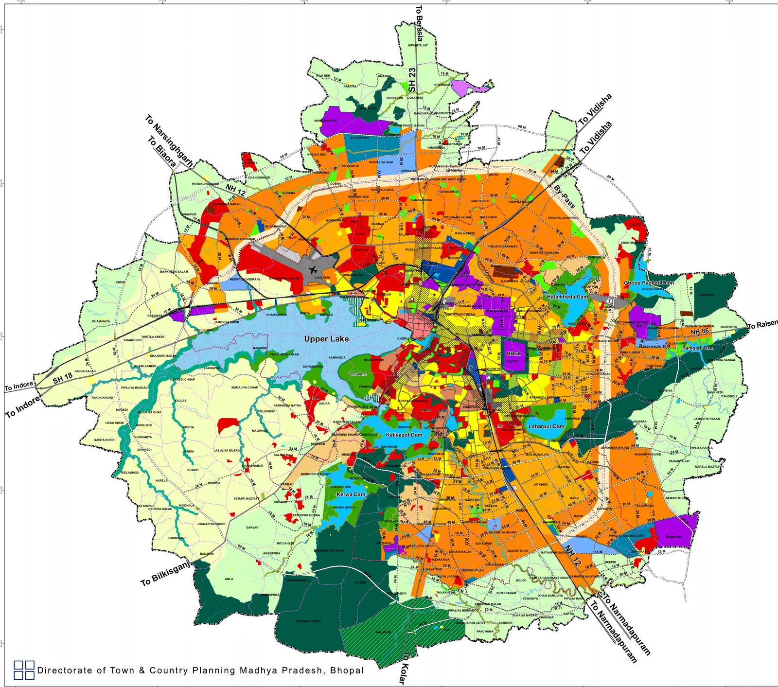
DRAFT Bhopal Development Plan 2047 draft land-use map: Upper Lake, NH-12, by-pass, growth corridor and zoning colours across the 1,016.90 sq km planning area Tap to zoom the map

Download the Bhopal Development Plan 2047 Draft Map

Free files, hosted here for public convenience. Pick the format that suits you.

PDF · Complete draft map

Draft Bhopal Development Plan - 2047 Booklet (PDF)

The complete published map sheet with the legend, scale and planning-area boundary. Vector quality, so you can zoom in on any village or road label.

PDF · A0 sheet · about 4.9 MB Download PDF
Image · Map + legend

ZONING Map 25 09 2047 khasra (JPG)

The whole sheet as one high-resolution picture — map on the left, zone legend on the right. Easy to share on WhatsApp or drop into a presentation.

JPG · 5056 × 3577 px · about 2.5 MB Download Image
Image · Map only

ZONING Map 25 09 2047 without khasra (JPG)

Just the map of the planning area, cropped tight. Best when you want to mark up your locality or attach the map to an objection or a note.

JPG · 2650 × 2342 px · about 2.2 MB Download Map Only

Want it on paper? Order a colour or B/W print in A0–A5 →  |  Official notice and documents: mptownplan.gov.in

Source: Directorate of Town & Country Planning, Madhya Pradesh — Bhopal Development Plan-2047 (Draft), Map No. 14.2, prepared by the Landuse & Urban Survey Division, Remote Sensing Application Centre, MPCST, Bhopal. Base data: World View II satellite data and archive master plan.

What is the Bhopal Development Plan 2047?

A development plan (often called a master plan) is the legal map that says what may be built where. It marks land for housing, shops and offices, industry, schools and hospitals, parks, forests and lakes, and it fixes how wide the main roads should be. Banks, builders, architects and ordinary plot owners all rely on it, because it shapes what a piece of land can be used for.

The Bhopal Development Plan 2047 is the new draft for the capital region. It was prepared by the Directorate of Town & Country Planning, Madhya Pradesh, and published in the last week of September 2026. It looks ahead to 2047 and covers an investment area of 1,016.90 sq km that includes 254 villages, planned for around 45 lakh people, with about 61,017 hectares of proposed developable land.

It is a draft. The government has invited claims, objections and suggestions from the public, and the plan can be changed before it is finalised and notified. That is why people across the city — residents, farmers, traders, developers, architects — are looking at the map to see how their own area has been marked.

Local tip: The Directorate of Town & Country Planning is headquartered at Paryavaran Parisar, E-5, Arera Colony — the same neighbourhood as our shop in Bittan Market. A large, clear print makes it far easier to read village names and road labels before you visit or write.

Key Proposals in the Draft, in Plain Language

A quick reading guide to what the Bhopal 2047 draft proposes, based on the government's summary and press reports.

Protecting Bhojtal, hills and forests

The plan puts the Upper Lake (Bhojtal) and its catchment first, with provisions for hills, forest areas, ponds, water bodies and tiger movement areas. The map marks three Bhojtaal Influence Zones (BIZ0, BIZ1, BIZ2) and an Eco-Sensitive Zone.

More green cover

Reports say green area is proposed to rise from about 16% to 27%. A Green TDR (transferable development rights) provision is meant to compensate owners of land that falls in green zones, while developers can use TDR for additional development.

A 51 km Growth Corridor

Roughly 3,000 hectares are proposed for a mixed-use, high-density corridor linking EKAI City (education, knowledge and AI), the airport, logistics and wholesale areas and suburbs. It is planned as a transit-oriented zone with a BRTS line that could later become MRTS.

Jobs and investment

The corridor is meant to host hotels, healthcare, IT, AI and data centres, logistics, wholesale trade, malls, corporate offices, education hubs and housing. Press reports say no FAR ceiling is proposed inside the corridor.

Mixed land use by road width

Officials say mixed use will be regulated according to the width of the road, while residential areas, the environment and the city's character stay protected. The map labels road widths such as 18 M, 24 M, 30 M, 45 M and 60 M.

Taller buildings, linked to roads

Permissible height and FAR are tied to plot size and access-road width, with separate norms for buildings up to 45 m and above 45 m. See the table below. A Digital Twin system is also proposed to monitor construction and illegal development.

01Conservation of the natural ecosystem
02Reform-oriented, transformative planning
03Modern, citizen-friendly planning
04Self-sustaining, economy-boosting development

Other ideas mentioned in press coverage include affordable housing, education hubs, a golf course and a new parking model. Some experts have said the plan needs clearer mechanisms for TOD, TDR, the sponge-city concept and groundwater recharge — which is one more reason to read the draft closely and submit your views on time.

Building Height & FAR Rules in the Draft

How much you can build depends on plot size and the width of the road it faces.

High-rise buildings above 45 m (as reported)
Access road widthMinimum plot areaMaximum FARMinimum front setback
36 m or more3,000 sq m2.7518 m
45 m or more3,500 sq m3.2518 m
60 m or more4,000 sq m4.0024 m
75 m or more4,500 sq mNo ceiling24 m

FAR = Floor Area Ratio, the total built-up floor area allowed compared with the plot area. Table as reported by the Free Press Journal on 27 September 2026 from the draft's provisions.

Other points reported

For buildings above 45 m the draft fixes a base FAR of 1.50, and the maximum rises with road width. A minimum open area of 30 m, stilt parking and paved (grass or perforated block) open space are also required.

For buildings between 12.5 m and 45 m, FAR ranges from 1.75 to 2.50 depending on road width — for example 1.75 on a 12 m road with a plot of at least 1,000 sq m, and 2.50 on a 30 m road with a plot of at least 2,500 sq m.

Buildings of 12.5 m and above must also meet structural, fire-safety, lift, electricity and parking requirements under the Madhya Pradesh Land Development Rules, 2012.

These are draft provisions and may change. Always confirm the exact rules in the official document before you plan or invest.

Zone Legend: What Each Colour on the Map Means

The codes and names below are taken straight from the legend of the draft map, so you can match colours to zones.

Residential

RG-IResidential General-I
RG-IIResidential General-II
RG-IIIResidential General-III
RG-IVResidential General-IV
RG-VResidential General-V
OCOld City

Growth, transit & mixed use

GCGrowth Corridor
TODTransit Oriented Development
CMU-ICommercial Mixed Use Center-I
CMU-IICommercial Mixed Use Center-II
CMU-IIICommercial Mixed Use Center-III
SPZ1Special Planning Zone-1

Industry, logistics & public use

I-1Industries-1
I-2Industries-2
LWLogistics, Wholesale and Warehousing
PUFPublic Utilities & Facilities
PSPPublic & Semi Public

Green, water & eco-sensitive

G1Gardens and Parks
G2Playfield / Stadium / Exhibition Ground
G3Zoological / Botanical Garden
G4Lake Front
G5City Forest / Afforestation
ESZEco-Sensitive Zone
WWaterbodies
WBWaterbodies Buffer

Bhojtaal influence zones & rural

BIZ0Bhojtaal Influence Zone-0
BIZ1Bhojtaal Influence Zone-1
BIZ2Bhojtaal Influence Zone-2
VVillage / Gramin Aabadi
AGAgriculture

Transport symbols on the map: existing road, proposed road, bus stand, railway station, railway line, airport, airport extension, transport nagar, bridge and parking. Boundaries shown: planning area, village and municipal. Colours on your printout may differ slightly from these swatches depending on the printer.

How to Check Your Property on the Bhopal 2047 Map

Six simple steps to read the draft for your own plot, house or land.

  1. Print it bigTake a colour print in A1 or A0 so village names, roads and labels are readable. A3 or A4 works as a handy carry copy.
  2. Find a landmarkStart from something you know: the Upper Lake, NH-12, the by-pass, the airport, or a dam such as Kaliyasot, Kerwa or Laharpur.
  3. Locate your village or colonyVillage names are labelled across the map. The list further down this page shows every name printed on the sheet.
  4. Match the colour to the legendCompare the colour over your area with the legend to see the proposed zone, such as RG-II residential, CMU mixed use or AG agriculture.
  5. Read the road widthLook at the label on the road that serves you (18 M, 24 M, 30 M, 45 M, 60 M). Height, FAR and mixed-use rules depend on it.
  6. Confirm officiallyPlot-level questions need official records. Check with the T&CP office or a planner, and file any claim or objection through the official process.

भोपाल विकास योजना 2047 (ड्राफ्ट): मैप डाउनलोड करें और प्रिंट पाएँ

भोपाल विकास योजना-2047 का प्रारूप (ड्राफ्ट) प्रकाशित हो चुका है। यह अगले दो दशकों के लिए भोपाल के भू-उपयोग और विकास की रूपरेखा तय करता है। मुख्य बातें:

  • निवेश क्षेत्र 1,016.90 वर्ग किलोमीटर, 254 गाँव और लगभग 45 लाख अनुमानित आबादी।
  • भोजताल, पहाड़ियों, वन क्षेत्र और बाघ भ्रमण क्षेत्र के संरक्षण पर विशेष जोर; हरित क्षेत्र लगभग 16% से बढ़ाकर 27% करने का प्रस्ताव (समाचार रिपोर्ट के अनुसार)।
  • करीब 3,000 हेक्टेयर में 51 किलोमीटर लंबा ग्रोथ कॉरिडोर, जो EKAI सिटी, एयरपोर्ट, लॉजिस्टिक्स और थोक व्यापार क्षेत्र को जोड़ेगा।
  • सड़क की चौड़ाई के आधार पर मिश्रित भू-उपयोग, और ऊँची इमारतों के लिए FAR व ऊँचाई के नए नियम।
  • प्रकाशित प्रारूप पर दावे, आपत्तियाँ और सुझाव आमंत्रित हैं। अंतिम तिथि और प्रक्रिया के लिए आधिकारिक सूचना देखें।

अपनी ज़मीन या मकान का स्टेटस खुद देखने के लिए मैप की कॉपी लें। हमारे यहाँ A0 से A5 तक हर साइज़ में रंगीन और ब्लैक एंड व्हाइट प्रिंट उपलब्ध है।

व्हाट्सऐप पर ऑर्डर करें मैप डाउनलोड करें

Villages & Localities Labelled on the Draft Map

Looking for your village? These 245 names are printed on the draft map sheet.

Show all 245 village and locality names (A–Z)
  • Aamkheda
  • Acharpura
  • Adampur Chhawani
  • Ahmadpur Kalan
  • Akabarpur
  • Amarpura
  • Amjhira
  • Amla
  • Amrawad Kalan
  • Amrawad Khurd
  • Anantpur
  • Arhedi
  • Arwaliya
  • Babadiya Khurd
  • Badbai
  • Badjhiri
  • Bag Mugaliya
  • Bag Sevaniya
  • Bagaroda
  • Bagli
  • Bairagad Chichlii
  • Bairagadh Kalan
  • Bakaniya
  • Bamhori
  • Bandori
  • Bangrasia
  • Banjari
  • Bankhedi
  • Bansiya
  • Barkheda Bondar
  • Barkheda Nathu
  • Barkheda Pathani
  • Barkheda Salam
  • Barkhedi Kalan
  • Barkhedi Khurd
  • Barrai
  • Bavadiya Kalan
  • Beenapur
  • Behta
  • Berkhedi Bazyaft
  • Bhairopur
  • Bhaisakhedi
  • Bhanpur
  • Bhanpur Kekadiya
  • Bhauri
  • Bhawali Kheda
  • Bherupura
  • Bhoj Nagar
  • Bilkhiriya
  • Bilkhiriya Khurd
  • Bishankhedi
  • Borban
  • Borda
  • Borkhedi
  • Bundrkha Sadak
  • Chandanpura
  • Chandbad
  • Chandpur
  • Chandukhedi
  • Chhan
  • Chhapri
  • Chhawani
  • Chhawani Pathar
  • Chhola
  • Chichali
  • Chopda Kalan
  • Chor Sagoni
  • Chuna Bhatti
  • Damkheda
  • Dangroli
  • Deepdi
  • Dehari Kalan
  • Dehriya Kalan
  • Devalkhedi
  • Dhamaniya
  • Dharampuri
  • Dobra
  • Dobra Jagir
  • Doobdi
  • Doulatpur
  • Fanda Kalan
  • Fanda Khurd
  • Fatehpur Dobra
  • Gadiya
  • Gehukheda
  • Ghasipura
  • Ghat Khedi
  • Gol
  • Golkhedi
  • Gondarmau
  • Goura
  • Govind Pura
  • Gudari Ghat
  • Hajjampura
  • Halalpur
  • Haripura
  • Hatai Kheda
  • Hatai Khedi
  • Hinotiya Aalam
  • Hinotiya Kachiyan
  • Imliya
  • Imliya Jargar
  • Inayatpur
  • Intkhedi Chhap
  • Intkhedi Sadak
  • Islam Nagar
  • Jamalpura
  • Jamoniya Chhir
  • Jamoniya Kalan
  • Jatkhedi
  • Jhagariya Khurd
  • Jhiriya Kheda
  • Kajlas
  • Kalapani
  • Kalkheda Mendori
  • Kalyanpur
  • Kanasaiya
  • Kanchbavali
  • Kankariya
  • Karariya urf Sajdabad
  • Karhod Kalan
  • Katara
  • Khad Bamuliya
  • Khadaba
  • Khajoori Sadak
  • Khajuri
  • Khajuri Kalan
  • Khajuri Khurd
  • Khamkheda
  • Khamlakhedi
  • Kharkhedi
  • Kharpa
  • Kharpi
  • Khejada Baramad
  • Khejda Deo
  • Khetla Khedi
  • Khokariya
  • Khori
  • Khudaganj
  • Khurchani
  • Kodiya
  • Koh-E-Fiza
  • Kokata
  • Kolu Khedi
  • Kolua Kalan Narela Shankari
  • Kolua Khurd
  • Kotra
  • Kotrasultanabad
  • Koudi
  • Kurana
  • Kushalpura
  • Laharpur
  • Lakhapur
  • Lalpura
  • Lambakheda
  • Lasuliya Gusain
  • Laukhedi
  • Mahawadiya
  • Maholi
  • Mahua Kheda
  • Maksi
  • Mali Khedi
  • Malikhedi
  • Manikhedi Kot
  • Mastipura
  • Meerpur (Veeran)
  • Mendora
  • Misrod
  • Mitu Khedi
  • Mohammad Nagar urf Satti Khedi
  • Moondla
  • Mubarakpur
  • Mugaliya Chhap
  • Nabibag
  • Nandni
  • Narela
  • Narela Bazyafth
  • Narela Hanumant Singh
  • Naronha Sankal
  • Nayapura
  • Neelbad
  • Nevari
  • Nipaniya Jat
  • Nishatpura
  • Padariya Jat
  • Padhariya Sankal
  • Palasi
  • Panchama
  • Pareva Kheda
  • Parvaliya Sani
  • Parwaliyasadak
  • Pipaliya Berkhedi
  • Pipaliya Dhakad
  • Pipaliya Jahirpeer
  • Pipaliya Kunjadgarh
  • Pipalner
  • Piplani Chamaran
  • Pipliya Baj Khan
  • Pipliya Hatila
  • Pipliya Kesho
  • Pipliya Peden Khan
  • Pipliya Rani
  • Prempura
  • Puraman Bhawan
  • Rapadiya
  • Rasla Khedi
  • Rasuliya Ghat
  • Rasuliya Jagir
  • Ratanpur Sadak
  • Ratatal
  • Ratibad
  • Roji Beh
  • Rolukhedi
  • Rusalli
  • Sagoni Kalan
  • Saista Khedi
  • Salaiya
  • Samarda Kaliyasot
  • Samashgarh
  • Samaspura
  • Sankhedi
  • Sarvar
  • Satgadhi
  • Semara Kalan
  • Semari Bazyaft
  • Semari Kalan
  • Semari Khurd
  • Sevaniya God
  • Sewaniya
  • Sewaniya Onkara
  • Shahpur
  • Shahpura
  • Shantinagar
  • Shobhapur Jahej
  • Shyampur
  • Sidhdik Pur
  • Sikandrabad
  • Singarcholi
  • Singpur
  • Suhagpur
  • Sukhi Sewaniya
  • Suraiya Nagar
  • Teelakhedi
  • Thuakheda
  • Veelkheda Kalan

Spellings follow the labels on the official draft map and may differ from local usage. Some names appear more than once on the map for different settlements.

Bhopal Development Plan 2047: Frequently Asked Questions

What is the Bhopal Development Plan 2047?

It is the draft land-use and development blueprint for Bhopal, prepared by the Directorate of Town & Country Planning, Madhya Pradesh. It decides which zones are meant for housing, commerce, industry, public use, green cover and water bodies, how roads and transit are planned, and how tall or dense buildings can be. The draft covers an investment area of 1,016.90 sq km with 254 villages, planned for an estimated population of about 45 lakh.

Is the Bhopal Development Plan 2047 final?

No. What has been published is a draft. The administration has invited claims, objections and suggestions, and the plan can change before it is finalised and notified. Treat every zone, road width and rule on the draft map as proposed, not final.

When was the draft published?

The Madhya Pradesh government released the draft on 26 September 2026, according to news reports. The map sheet on this page (Map No. 14.2) is dated 25 September 2026.

How can I download the Bhopal master plan 2047 map?

Use the download buttons at the top of this page: the complete draft map as a PDF (A0 sheet), the full sheet as an image with the legend, or the map-only image. All three are free. For the official notice and documents, use the Directorate of Town & Country Planning portal at mptownplan.gov.in.

How do I file an objection or suggestion on the draft?

The government has invited public claims, objections and suggestions on the published draft. The last date and the exact procedure are set in the official notice, so please check the Directorate of Town & Country Planning portal or your local T&CP office before you prepare your submission. A clear print of the map helps you mark the area you are writing about.

How do I check my plot or house on the draft map?

Print the map in a large size (A1 or A0 works best), find a landmark such as the Upper Lake, NH-12 or the by-pass, then trace your area. Read the colour against the legend to see the proposed zone, and read the road-width label (18 M, 24 M, 30 M and so on) on the road that serves you. Plot-level decisions need the official records, so confirm with the T&CP office or a planner before you act.

Which sizes can I get printed at Hexagon Photostat?

We print every size from A0 to A5, in colour or black & white. Because the map is dense with village names and road labels, most customers choose A1 or A0 for reading detail and A3 or A4 for a handy copy. Lamination and spiral or hard binding are available too. Message us on WhatsApp for timing and rates.

Should I choose a colour or a black & white print?

Choose colour if you want to read the zones, because the legend is colour-coded and greys are hard to tell apart. Black & white is fine for a working copy where you only need village names, roads and boundaries.

Is the file on this page the official document?

It is the draft map sheet (Map No. 14.2) published by the Directorate of Town & Country Planning, Madhya Pradesh, shared here for public convenience. The draft may be revised, so always compare with the official portal. Hexagon Photostat is a print shop, not a planning authority.

What is the growth corridor in the Bhopal 2047 plan?

It is a proposed 51 km mixed-use, high-density belt of roughly 3,000 hectares that links suburbs, the airport, logistics and wholesale areas and a proposed education, knowledge and AI hub called EKAI City. It is planned as a transit-oriented zone with a BRTS line that could later be upgraded to MRTS.

Sources

Disclaimer: This page summarises a draft government document and press reports for public information. It is not legal, planning or investment advice, and the draft may change before it is finalised. Verify every detail with the official notice and documents. Hexagon Photostat is a print shop and is not affiliated with the Directorate of Town & Country Planning or the Government of Madhya Pradesh.

Take a copy. See your property status on the Bhopal 2047 draft — yourself.

Order a Print Download the Map